Outside of the amazing geologic features there is something about ancient peoples, RD Swasey’s cowboys, and a couple dinosaur footprints that draws visitors to the San Rafael Swell. We’re intrigued by past inhabitants and the way individuals interacted with the land.
Directly jump to:
Must See
Camping
Tips and Logistics
Directions
Near by Attractions

~spend about 15-30 min~
History
Cowboys
One of my favorite cowboy stories from the Swell happened in the late 1800’s–it involves brother’s placing a bet, a 12 ft. jump over an 80 ft. drop on a horse, and a small herd of cattle that was handed from one cowboy’s hand to another’s.
Anyone else wonder what was going through that horse’s mind as it neared the edge of the cliff?
Word has it that Sid Swasey bet his brother Charley his share of the cattle if he could jump the canyon on his horse. As the story goes, Sid accomplished the leap earning both his brother’s share of the cattle and the name of the canyon which today is still called “Sid’s Leap”. Other versions of the story suggest that Sid made the jump fleeing from the law after robbing participating in the Castle Robbery in Carbon County and an additional tale suggests that he had nabbed the Sheriff’s saddle and was running from him. Whichever way, much of the area surrounding the San Rafael Swell is named for or by the Swasey boys because of their abundant time in that region.
Sid, Charley, Joe and Rod were the oldest sons of Rodney Degrass Swasey, an owner of a large cattle herd and a plot of land in Southern Utah. Cowboys had been running cattle through this area for decades before the Swasey Cabin was built to provide temporary lodging for the small cattle crew. The cabin, built in 1920, still stands today.
Indians
Long before the Swasey’s, a group — or several groups — of hunters and farmers spent time in the San Rafael Swell. Obvious evidence of their presence includes corn that was carbon-dated to about 2,340-1,940 years ago, pictographs, and traces of their homes. Historians and anthropologists have taken to calling these people the “Fremont”. Little is known about these people, and the title seems to stretch over scattered peoples in the region who might have actually been apart of distinct and separate groups.
San Rafael Swinging Bridge built in the 1930’s by the Civilian Conservation Corps to aid cattle in crossing the river. (PC: Library of Congress)
Present Day
Many of the features at the San Rafael Swell today include:
Lone Warrior, Swasey’s Cabin, Dinosaur Tracks, Eagle Canyon Arch, Wedge Overlook (aka little Grand Canyon), Petroglyphs and Pictographs, Eagle Canyon Bridges, Goblin Valley, little Wild Horse Canyon, Eagle Canyon, and the San Rafael
Activities are very much your responsibility but ideas might include, Kayaking or slowly tubing down the 11 mile river, hikes, mountain biking, riding a horse and/or camping.
Must See
One Day
- Take a look at this website for Detailed Off-Roading ideas
- FUN HIKE: 4-6 hours going up either Bell or Little Wild Horse. While it doesn’t require technical canyoneering skills it’s a loop of easy to moderate intensity that requires some good basic scrambling skills to maneuver around a few chokestones. Obstacle-course-like hikes are my favorite as they add another layer of excitement. If you’re planning on going with your family or younger children I know there are some 10 year-olds out there that are definitely component enough for this hike, but it’s also fun for a bunch of young adults. More detailed information in this FREE pdf travel guide and this hiking website. (1.8 miles to top of the narrows or 7.8 for complete loop)
- Hiking inside the ‘Little Grand Canyon’ is a classic way to go. You decide how long you want to be there, and simply follow the river through the winding slots. You might even find a couple places with evidence of ancient Freemont habitations.

One Hour
- The Wedge overlook or “Little Grand Canyon”.
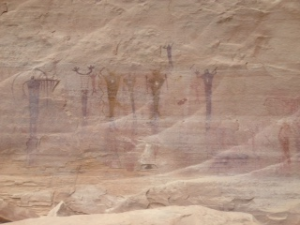
- 2000 year old Buckhorn Draw Pictographs, pull right up to them in your car!
- Dinosaur footprint imprinted in the stone: Stick your hand, foot, or both in the foot print of a dinosaur’s.
- .5 mile hike to the Rochester Creek Rock Art Panel

~you might spend about an hour ~
Buckhorn Draw Road features well over a hundred feet of painted rock captured by two cultures from different time periods. The area has parking, visitor register and a series of interpretive notices.
Camping
There are a couple options directly inside the park:
-Boondock – Free/First come first serve sites
(identifiable by the fire rings)
–Fee based campsites
located near the Swinging Bridge
(east end of the Little Grand Canyon).
-This site contains additional information on near by campsites and/or RV parks.

An example of one of the boondocking primitive camp sites is just off the road in Buckhorn Wash. It has:
-Easy Vehicle access
-A simple fire ring
-No water
-One restroom facility without a roof or toilet paper. Try to bring one of those things 😉
The campsites will range from primitive to the odd one with a table, to the Bureau of Land Management fee campground which includes: fire pit, toilets, tent pads, and a picnic table. There are no reservations.
Tips and Logistics
- Entrance is FREE
- ‘Pack it in Pack it out’ courtesy rules
- Isolated area so make sure you bring necessary supplies
- Lots of water (especially in hot winter months)
- First Aid kit
- A car with a full tank of gas
- Fire wood if camping
- Toilet paper
- Sometimes cattle wander onto the roads, stay attentive.
- The San Rafael Swell is open to the public all year round, but the roads can get quite muddy or quickly flood. Avoid travel during a storm. If you do get caught in a storm, it’s suggested that you wait it out. Desert roads tend to dry quickly.
- Much of the roads are gravel or dirt and the signs are not always distinct. Consider taking a map or GPS to rely on for directions. This map has a nice illustration of the different sites and roads.
- This is a SUPERB travel guide focused on the San Rafael. I just had to share it.
- There are no services inside the swell, and cell phone service may be spotty.
- The best time to go is during the Spring and Fall months when the weather isn’t too extreme.

Directions
Swasey Cabin:
- From I-70 take Ranch Exit 129.
- Head west and south from Exit 129 for four miles.
- Turn right and continue for 1.1 miles.
- Turn right again and travel in a northwesterly direction for about four miles.
- Continue along the road in a southerly direction for two miles.
- Turn right (west) and drive 0.6 miles to the cabin.
Rochester Rock Art Panel:
- Between Emery and Ferron on UT-10, find the turnoff between mile markers 16 & 17;
- Go east on Co Rd 801.
- Take Co Rd 801 to Co Rd 805 and turn right. (0.5 miles)
- Follow Co Rd 805 to the trail head. (4 miles)
Directions to Buckhorn Draw Pictograph Panel:
From the North:
- Right before the town of Castle Dale, at milepost 39.4, go east on the signed San Rafael Swell Access road.
- Continue on this road, passing a cattle guard after 12 miles, and reaching a 4 way junction at 12.7 miles.
- Continue east at this 4 way junction for 2.4 miles to the signed Buckhorn Wash road. Turn right to go down Buckhorn Wash.
From the South:
- From Green River take I-70 west for about 30 miles,
- Take exit 131 turning right. This road goes east, paralleling the freeway for a couple of miles before turning north.
- Follow this road for 19 miles to the San Rafael campground, and the bridge over the river. The cattle guard marks the lower end of Buckhorn Wash.
Directions to Wedge Overlook:
From Price
-about an hour drive south of Price
1. Take UT-10 S to UT-155 S and turn left. (11.2 miles)
2. Take UT-155 S to Flat Bus Loop and turn left. (7.6 miles)
3. Take Flat Bus Loop east to Co Rd 208 and turn right. (0.3 miles)
4. Take Co Rd 208/206 to Victor Reef Rd and turn right. (3.5 miles)
5. Take Victor Reef Rd to Buffalo Rd and turn left. (2.1 miles)
6. Take Buffalo Rd/Buckhorn Draw Rd/Fullers Bottom Rd to Wedge Rd and take a slight left. (7.1 miles)
7. Take Wedge Rd to Wedge Overlook. (6 miles)
From Castle Dale
-about a 40 minute southeast drive
1. Drive east out of town on Main St/UT-10 to Green River Cutoff Rd and turn right. (1.5 miles)
2. Take Green River Cutoff Rd/UT-401 east to Buckhorn Information Center and turn right on Fullers Bottom Rd. (12.8 miles)
3. Take Fullers Bottom Rd south and take a slight left onto Wedge Rd. (0.5 miles)
4. Take Wedge Rd to Wedge Overlook. (6 miles)
Little Wild Horse Canyon:
- Follow I-70 E/US-50 E to Temple Mt Rd in Emery County
- Take exit 131 from I-70
- After about 15 min. turn right onto Temple Mt Rd
- As you head west turn south before the reef onto Goblin Valley Road
- After a few miles turn west on a recently paved side road just before the state park.
- 3 miles later you’ll see the small parking lot in front of the Little Wild Horse trail head. You will also see a trail map and a register for the hike.
Near by Attractions
Goblin Valley:
1. From I-70, take exit 149 onto UT-24 W.
2. Take UT-24 W to Temple Mt Rd. (23.8 miles)
3. Turn right on Temple Mt Rd and follow it west to Goblin Valley Rd. (5.2 miles)
4. Turn left on Goblin Valley Rd and follow signs to the park. (6.7 miles)
Cleveland-Lloyd Dinosaur Quarry:
FROM PRICE:
1. Take Hwy 10 S to the Cleveland/Elmo turnoff and follow the signs.
2. The last 12 miles are on a graded, unpaved road.
FROM HUNTINGTON:
1. Follow Hwy 10 N and take the Cleveland turnoff.
2. In Cleveland, go south toward the San Rafael Swell and follow the signs. 3. The last 13 miles are on graded, unpaved road.