“Make handcarts, and let the emigration foot it and draw upon them [the carts] the necessary supplies, having a cow or two for every 10. They can come just as quick, if not quicker, and much cheaper…” -Brigham Young
History of Martin’s Cove

Migration Disaster and Heroism
In 1856, close to 1,500 people in the Martin and Willie handcart companies and the Hodgetts, Hunt, and Smoot wagon companies became stranded on the high plains of present-day Wyoming in the dead of winter. These groups were members of The Church of Jesus Crist of Latter-day Saints migrating from Iowa to present-day Utah to join with many others of their faith. These groups however had left Iowa late in the year and faced an early snowy winter, ran out of food and suffered from extreme exposure to cold blizzards and exhaustion. Over 250 people died from the conditions and others were deformed from frost bite. This event is known as one of the greatest westward migration disasters in the United States. It was an exceedingly hard journey–particularly for the handcart companies who were walking on foot and carrying all of their belongings and food by hand.
Martin’s Cove
In the beginning of November, the Martin handcart company–about 500 Latter-day Saint emigrants primarily from the British Isles–made camp in ‘Martin’s Cove’, because the cold wind and snow made it too dangerous to proceed to their destination about 330 miles away. A few days prior to their arrival they had been discovered by a small rescue team searching for them. They decided to wait in a natural cove or bend in a small group of foothill for further help so that those who were too frail to walk could be carried in wagons.
At the start of their journey, the handcarts were supplied with 90 days worth of food with the expectation that the trip would take 70 days and that they would cover 20-30 miles each day. However, in the end the Martin handcart company would take 107 days, (with 21 of those days assisted by wagons from rescue efforts). With the end far from sight, food rations were continuously cut through out this long journey. 61 days in it decreased to 8 oz of flour/adult, then on to 4 oz of flour/adult 11 days later. They day rescue teams arrived with food, the Martin handcart company had nothing left. All this happened whilst traveling through freezing rivers, treading through several feet of snow, and carrying all their belongings on foot.
The Original Plan
Early members of the Church of Jesus Christ were continually driven from their homes and found it difficult to locate a place they could gather without intense religious persecution. After leaving behind home after home and going so far as Utah to establish their new Zion, the members and the church created a program called the Perpetual Emigration Fund (PEF). This was in part a result of the “covenant” of 1846 when the church members left Nauvoo, III., and pledged to never desert “the poor who are worthy”.
In the beginning, the PEF was stocked with $5,000 to aid future impoverished converts on their westward migration to the State of Deseret. The hope was that after the money was used to get poor members to the State of Deseret–and those people reestablished themselves–that they would then put money back into the PEF to help other with ther journey. With a large influx of converts from the British Isles and the Eastern United States, this fund proved to be too small to meet its demand and the system too slow in the replenishment of it that other methods were needed to get the Saints to Deseret.
Hand Carts
In September 1855 Brigham Young fell back on an old plan–“to make handcarts, and let the emigration foot it and draw upon them [the carts] the necessary supplies, having a cow or two for every 10. They can come just as quick, if not quicker, and much cheaper…”
It was no secret that this would be a difficult journey. Handcarts were small compared to wagons, constructed with two wheels, and pulled and pushed by hand as the name suggests. There were about five people to a handcart, and only about 15-17lbs of possessions per person.

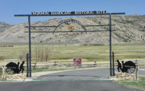
Present Day
Today the Church of Jesus Christ has developed adjoining property to the actual “Matins Cove”. The Church of Jesus Christ owns property which includes a historic ranch house that houses the Mormon Handcart Visitors Center. With interpretive displays and numerous volunteers this center is the the starting place for your visit to the area. Water, a large parking area and well cared for grounds surround a number of ranch buildings. Parking your RV or trailer is easy in the parking area. From this main visitor area runs a trail to the actual Martins Cove that is situated on the BLM land near the ranch houses. The short (well a 2.5 mile) hike takes you to the actual site and is worth the hike but depending on the time of year can be a challenge for those with mobility issues. The trail also goes past the Monument and Rescue Sculptures that were dedicated in 1992. There are also two campgrounds, and the land where Fort Seminoe used to stand. Families and organizations can use the grounds for camping or trek reenactments. For more information on how to reserve a spot/time please view the church’s website.
At the ranch site, there is a visitors center run by church volunteers. It is a great place to the learn the history of Martin’s Cove. Additionally, as seen in the picture above, handcarts are available, free of charge, and visitors can pull them around the area. This is a popular activity and gives the participant a real perspective on a difficult and alternative way to travel. You will gain a quick respect for those that pulled these cumbersome carts nearly 1/2 way across this country.
Many accounts and stories are retold of the event at Martin’s Cove, including miracles that came in the midst of incredibly difficult circumstances. Two popular movies, ‘Ephraim’s Rescue‘ and ‘17 Miracles‘, recount some of the miracles and heroic efforts that transpired in this area during this tragic event. After walking the dust trails pulling a hand cart over a rocky trail you will want to learn more of what happened here.

Tips and Logistics
Limited Hours
Monday–Saturday
9:00 a.m.–5:00 p.m.
Sunday
2:00 p.m.–5:00 p.m.
You may want to
confirm time by phone
Phone:
1-307-328-2953 (Main)
Tips to better prepare:
1. There’s a significant chance that you will not have cell phone service at this location.
2. There are many ‘No Dogs Allowed’ signs. Plan ahead if you have pets!
3. Bring mosquito repellent in the mid-late summer months.
4. RV Parking is Fair to Good at this location.
5. Bring your own food. There are no places to buy food in the area. Water is available.
6. Weather: Winter is cold here. Summer is hot.
Directions
Address:
Martin’s Cove, 47600 West
Hwy 220
Alcova, WY 82620
Camping Option: Ranch 66 Missionary Village
Located 10 miles west of Martins Cove. A mile or so north off HWY 220. Marked with a sign. It is where many volunteers at the Visitor Center stay during their time here.
Hwy 220
Muddy Gap, WY 82301
307-328-2953
Nearby Attractions
Devil’s Gate

Devil’s Gate is a couple miles from Martin’s Cove. Just past Devil’s gate is the place where the Willie Handcart Company was trapped in the same storm. Both groups were rescued by wagons sent by Brigham Young and volunteers across the Deseret region.
This natural formation was a major trail landmark for many decades. Many talk about seeing big horn sheep climbing its incline, and some climbed the granite a bit to engrave their names in the stone.
Independence Rock
![]()
![]()
![]() Independence Rock is a rounded monolith and historic site in Alcova, Wyoming. It was named ‘Independence Rock’ after an independence day celebration with William Sublette and 80 other pioneers. What makes it a historic site? In addition to its past correlation with an Independence day celebration, it is also thought of as the ‘Register of the Desert’ as thousands of pioneers traveling west signed their names on it as the passed. In fact, names were added to its smooth surface for continuous decades spanning back to at least 1824.
Independence Rock is a rounded monolith and historic site in Alcova, Wyoming. It was named ‘Independence Rock’ after an independence day celebration with William Sublette and 80 other pioneers. What makes it a historic site? In addition to its past correlation with an Independence day celebration, it is also thought of as the ‘Register of the Desert’ as thousands of pioneers traveling west signed their names on it as the passed. In fact, names were added to its smooth surface for continuous decades spanning back to at least 1824.
This landmark was fairly well known among travelers; many made it a goal to get to it by July to ensure that they would reach their destination (often present-day California, Oregon or Utah) before the first mountain snowfalls hit.

